Transforming Mineral Exploration: Breakthroughs in Drone-Based Hyperspectral Imaging
Article published by Dawn Zoldi at Autonomy Global on January 1, 2025.
In a groundbreaking development for the mining industry, researchers at North Dakota State College of Science (NDSCS) and the Center to Advance the Science of Exploration to Reclamation in Mining (CASERM) at the Colorado School of Mines have successfully harnessed the power of drone-mounted hyperspectral imaging to transform mineral exploration. This cutting-edge technology enables rapid, non-invasive, and highly accurate mineral prospecting, potentially revolutionizing how mining companies discover and map mineral deposits worldwide.
Leading the Charge in UAS and Geoscience Education
Founded in 1903, NDSCS holds a distinguished position as the second oldest public two-year college in the United States. NDSCS additionally boasts a rich history in aviation education as one of the first institutions in the country to offer aviation programs.
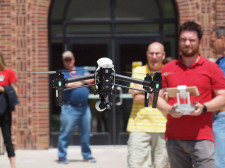
Building on this legacy, NDSCS embraced UAS as an early adopter. In the fall of 2017, the college began offering classes in this technology. This quickly expanded into what has now become offerings of a comprehensive two-year Associate of Applied Science degree and a one-year certificate program.
According to Seth Simonson, Associate Professor and Program Lead for Land Surveying, Civil Engineering Technology, and Unmanned Aircraft Systems at NDSCS, its programs focus on commercial end-user applications through classroom and experiential learning. Specifically, they provide students with hands-on training in various UAS applications, including: photography, videograph, photogrammetry, LiDAR, thermography and multispectral and hyperspectral imaging. As part of the curriculum, NDSCS also exposes students to UAS-enabled research.
This holistic and practical approach prepares graduates to enter the workforce as pilots, data analysts or technicians for a wide range of industries utilizing UAS technology.
Hyperspectral Imaging: The Next Frontier in Mineral Detection
Given NDSCS’ reputation for UAS research, in 2022, the National Center for Autonomous Technology (NCAT) approached the college with an opportunity to partner with it and the Colorado School of Mines to explore the use of hyperspectral imaging on a UAS platform. The National Science Foundation (NSF) supported this initiative with grant funding. This enabled the purchase of the necessary equipment and funded overall research activities.
Hyperspectral imaging, an advanced remote sensing technique, captures information beyond the visible spectrum across a continuous range of wavelengths. Unlike traditional multispectral imaging, which focuses on specific bands such as red, green, blue, near-infrared, and red edge, hyperspectral imaging, it provides a much more detailed spectral profile.
Advanced Equipment: Inside the Drone-Based Hyperspectral System
The hyperspectral sensor used in this research project, the HySpex Mjolnir VS-620, a state-of-the-art hyperspectral camera system developed by the Norwegian company HySpex, operates in the range of 400 nanometers to 2500 nanometers. This advanced system comprises two separate cameras: a visible and near-infrared (VNIR) camera that covers the 400-1000 nm range with 200 spectral bands and a short-wave infrared (SWIR) camera that operates in the 970-2500 nm range containing 300 spectral bands. Combined, these cameras collect data across 490 total narrow, contiguous spectral bands. This high spectral resolution allows for the identification and mapping of specific minerals in unprecedented detail based on their unique signatures.
The integration of a Velodyne VLP-32 LiDAR sensor to capture high-resolution topographic data further enhanced the team’s system. This combination of hyperspectral and LiDAR sensors allows for the creation of detailed 3D models of the terrain which remains critical for accurate analysis of the hyperspectral data.
The entire system is mounted on a BFD SE8 drone outfitted with a Gremsy AEVO gimbal (the team previously used the H16) for stability and precise control. The integration of an Applanix APX-20 IMU (Inertial Measurement Unit) ensures accurate positioning and orientation data for each captured image.
Overcoming Challenges: Field Testing in Diverse Mining Environments
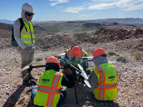
The research team conducted initial projects in Idaho’s Cobalt Belt in 2022. They immediately faced flight challenges related to high elevations and heavy payloads. These early experiences provided valuable insights and led to improvements in later missions.
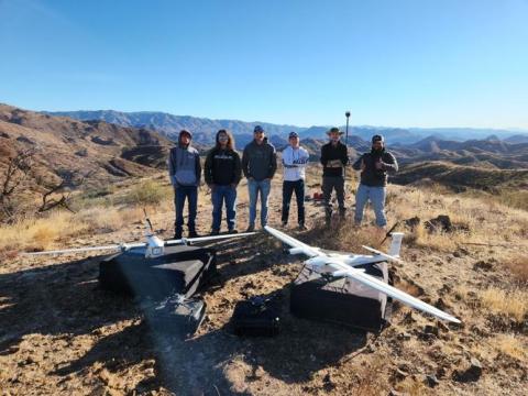
In March 2023, the project expanded to a two-week field campaign that focused on two mine sites: the Kay Mine in Arizona, located about an hour north of Phoenix, and Castle Mountain, situated on the California side of the Nevada border, an hour and a half southwest of Las Vegas.
During the Arizona portion of the project, the expedition encountered an unexpected hurdle when the hyperspectral camera, sourced from Norway, became delayed in Customs. This setback at the Kay Mine site prompted the team to adapt their plans. They used the opportunity to conduct high-resolution photogrammetry mapping of a large portion of the mine site using multi-rotor and fixed-wing drones equipped with standard cameras.
At the Castle Mountain site, they had the hyperspectral camera on board the aircraft and the data collection began in earnest. The process consists of a delicate balance of precision and adaptability. They operated the UAS at an altitude of 120 meters (approximately 390 feet) above ground level and flew at a speed of 2.5 meters per second. Flight lines were carefully planned with 32-meter spacing to ensure adequate coverage and overlap. Altitude and sensor availability issues aside, the nature of hyperspectral imaging, even under perfect conditions, presents unique challenges. Flight duration ranks high among them. The weight of the equipment, which necessitates multiple battery changes and careful mission planning, generally limits flights to approximately 10 minutes.
Environmental factors can also significantly impact data quality. Ideal conditions require specific sun angles, minimal cloud cover and dry ground surfaces. This limits data collection to windows outside of early morning and late afternoon hours, to ensure optimal lighting conditions.
Simonson explained, “Hyperspectral imaging is very sensitive to different environmental factors. The sun angle has to be correct. Clouds have to be minimal or pretty much nonexistent. We can’t fly if it’s just rained because there’s moisture on the ground evaporating, which causes issues with our imaging.”
To manage some of the environmental challenges, the team employs a dual-computer setup during flights. One computer controls the drone’s flight path, while another operates the HySpex Air software, This enables real-time monitoring and to adjust the camera’s exposure settings.
Data Processing: Turning Raw Imagery into Actionable Insights
The workflow for collecting, and then processing, hyperspectral data is also a complex and time-consuming process. First, as discussed above, hyperspectral cameras and LiDAR sensors must ingest the data. Then orthorectification, which corrects geometric distortions inherent in push-broom sensor data, must occur. Atmospheric corrections must also be made to minimize the impact of atmospheric conditions on the captured spectra. Then, LiDAR data gets integrated to create accurate digital elevation models. The next step involves spectral analysis and mineral mapping. To transform raw data into actionable insights, the research team utilizes a variety of software packages. This comprehensive approach ensures that the final product is a geometrically accurate, atmospherically corrected hyperspectral image that can be used for detailed mineral analysis.
Drone vs. Traditional Methods: The Competitive Edge in Mineral Exploration
Despite the inherent challenges in using UAS for hyperspectral imaging, the coupling of these technologies offers distinct advantages over traditional satellite or high-altitude aircraft methods.
UAS-mounted sensors can achieve resolutions of 6 cm in the VNIR range and 12 cm in the SWIR range at an elevation of 120m.. This is significantly higher than satellite imagery (30 m resolution) or high-altitude aircraft (1 m resolution). Better quality data translates into more informed decision-making.
Teams can quickly deploy UAS to scan active mining sites, exploratory areas, and tailings facilities, providing timely data for decision-making. This level of flexibility provides a significant value-add to using them. Speaking of flexibility, unlike satellite or aircraft-based systems, UAS can be easily maneuvered to scan vertical mine faces. This provides valuable data on exposed mineral veins and geological structures.
Finally, for smaller areas or frequent monitoring, UAS-based hyperspectral imaging can be more cost-effective than commissioning satellite or aircraft surveys.
Future Innovations: Enhancing Drone Capabilities for Mining Applications
The ongoing collaboration between academic institutions like NDSCS, the Colorado School of Mines and industry partners continues to drive innovation in this field. It promises exciting developments in the future of mineral exploration and environmental monitoring.
As the field of drone-based hyperspectral imaging for mineral exploration continues to evolve, Simonson expects to see improvements across several areas. For one, his team is actively working on solutions to increase flight duration. This includes exploring higher-capacity batteries and seeking FAA waivers for increased weight limits. Improvements in environmental adaptability remains a priority. Efforts must focus on developing methods to mitigate the impact of environmental factors on data quality. Streamlining the post-processing workflow through automation and machine learning techniques could significantly reduce the time from data collection to actionable insights. Combining hyperspectral data with other sensing modalities, such as magnetometry or ground-penetrating radar, could provide even more comprehensive geological insights.
In the meantime, as the field continues to evolve, the combination of UAS and hyperspectral imaging promises to unlock new possibilities for resource discovery and sustainable mining operations.
For more information about this research project or the UAS program at North Dakota State College of Science, please contact: Seth Simonson Associate Professor North Dakota State College of Science.
Email: seth.simonson@ndscs.edu
Phone: (701) 671-2345.


 The Business and Marketing emphasis area will provide students with knowledge on business and marketing practices along with communication and presentation skills.
 The Civil Engineering Technology Emphasis will prepare students for work as civil technicians in construction related industries with the ability to utilize drone technology.
 The Construction Inspection emphasis area will provide students with knowledge of construction practices, construction specifications, print reading, construction document management, material testing, and quality control practice.
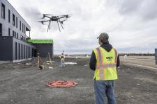 The Land Surveying Emphasis will prepare students for work as surveying technicians in construction related industries with the ability to utilize drone technology.
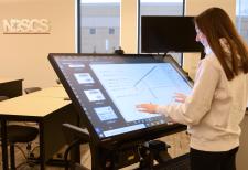 With the Architectural Modeling Emphasis, in addition to the UAS courses, students will take multiple modeling courses using Autodesk Revit software. Construction methods and materials and print reading courses will also be included in the program for students to have a good knowledge of construction and ability to read prints.
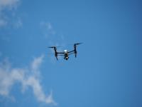 The Transfer Emphasis will provide students with a strong knowledge and skills for various applications of drone technology and compliment them with general education courses suited for transferring to a university for drone related studies.