NDSCS Unmanned Aircraft Systems students participate in an NSF-funded research project

Land Surveying students at work on drone
04-04-2023

North Dakota State College of Science (NDSCS) recently collaborated with the National Center for Autonomous Technologies (NCAT) and the Colorado School of Mines to provide a group of seven students from NDSCS’s Unmanned Aircraft Systems certificate program with a unique 16-day fieldwork experience. The students traveled to Arizona and Nevada in March, where they used drones to collect data from mining sites using hyperspectral imaging, a technology that captures data from across the electromagnetic spectrum beyond the visible light our eyes can see.

The trip was funded by a National Science Foundation (NSF) grant secured by NCAT, whose mission is to educate technicians for careers in autonomous technology fields. The grant covered all travel expenses for the students and provided them with a stipend for their work.

NDSCS students were responsible for planning missions, flying drones, and collecting data. Seth Simonson, NDSCS associate professor, accompanied the students and led curriculum development for the UAS component of the project. Graduate students from the Colorado School of Mines evaluated the data collected to identify and quantify material in the mines. The group from NDSCS spent eight days outside of Phoenix, Ariz., and eight days in Henderson, Nev. traveling approximately 60 miles southwest from there into California, to complete their fieldwork. The primary drone used for the project was a $70,000 quad drone equipped with a $300,000 camera that collects 490 wavelength bands. This was the NDSCS students’ first time using a camera with this level of spectral range. “Getting flight time with this high-performance camera was an incredible learning experience for the students,” said Simonson. “It sparked a lot of interest in the future of the industry.”

The NDSCS students who participated in the study included:

  • Tyler Cunningham, Land Surveying and Civil Engineering Technology, Thompson, N.D.
  • Annah Evavold, Architectural Modeling and Design Technology, Battle Lake, Minn.
  • Bailey Goschke, Land Surveying and Civil Engineering Technology, Oslo, Minn.
  • Mark Jenniges, Land Surveying and Civil Engineering Technology, Brooten, Minn.
  • Joel Kavaloski, Land Surveying and Civil Engineering Technology, Lindstrom, Minn.
  • Noah Cunningham, Land Surveying and Civil Engineering Technology, Minot, N.D.
  • Trenton Thomasson, Land Surveying and Civil Engineering Technology, Fargo, N.D.

In addition to working with advanced technology, the students valued working in different terrain. “Around here, it’s all flat land. Out there, it’s desert and mountains,” said Mark Jenniges. “You had to pick out your vantage points. You had to figure out how you were going to plan your missions so that you didn’t wreck or lose sight of your drone because you always have to have a visual line of sight. You had to pick out take-off and landing spots–it was all very valuable experience.”

The trip also allowed students to collaborate with other professionals. “We were in the field doing a job,” said Annah Evavold. “It was our job to collect the data so the researchers could do their part in the project. We had to know what we were doing and we took it seriously.”

Joel Kavaloski said he enjoyed working with the graduate students. “The geologists explained the science behind why we were capturing the data. We knew where the drones could fly, but we didn’t necessarily know their points of interest. They helped us understand the bigger picture.”

“Overall, it was just a great work experience for us,” said Tyler Cunningham. “If future employers see that on a resume, I think they’ll take into consideration the time we spent planning missions and developing flying skills.”

This collaboration between NDSCS, the Colorado School of Mines, and NCAT demonstrates the importance of partnerships and the potential for groundbreaking research when institutions come together. Simonson looks forward to future runs of the study where he will continue to lead the UAS curriculum.

The success of this project also demonstrates how UAS is one of the fastest-growing industries with new applications constantly being identified. In response to emerging careers in unmanned aerial technologies, NDSCS is expanding its UAS certificate program into a standalone associate degree. Starting in the fall of 2023, NDSCS will offer an Associate in Applied Science degree in Unmanned Aircraft Systems with six emphasis areas including Land Surveying, Civil Engineering Technology, Architectural Modeling, Construction Inspection, Business & Marketing, and Transfer. Through a hands-on curriculum, students will learn about unmanned aircraft types, legal operational guidelines, preflight planning, piloting UAS, and collecting and processing data through photogrammetry, thermography, multispectral imaging, LiDAR, photography, and videography. Students also earn a Federal Aviation Administration (FAA) Remote Pilot Certificate preparing them to become remote pilots in different commercial environments and industries. Simonson said the FAA supports NDSCS’s expanded curriculum because of its industry focus and hands-on approach. “Students use UAS to collect and process data just as they would in industry, which distinguishes our program.”

Additional information about the NDSCS Unmanned Aircraft Systems program can be found online at NDSCS.edu/UAS.

Article written by NDSCS and submitted to external news outlets. 

NDSCS announces partnership with SITECH Dakotas

SITECH partnership
11-01-2017

North Dakota State College of Science announced a partnership with SITECH Dakotas, a division of Butler Machinery, to provide state-of-the-art equipment for the College’s Land Surveying and Civil Engineering Technology department. Each academic year, SITECH Dakotas will provide NDSCS with the latest equipment to be used at no cost. SITECH Dakotas will also provide training and technical support for faculty to effectively operate the equipment. The equipment will be returned at the end of each academic year, to be replaced with updated equipment the following year.

SITECH Dakotas has currently entrusted NDSCS with the following equipment, valued at approximately $35,000: Trimble GPS Base, Trimble GPS R10 Receiver and Trimble Data Collector.

“This partnership allows our program to be more efficient,” said Jeff Jelinek, NDSCS Land Surveying and Civil Engineering Technology Program Coordinator. “We are able to have more students working hands-on with equipment at the same time.”

In spring 2018, SITECH Dakotas will provide two additional GPS receivers, a machine display and mounting brackets to NDSCS, adding $60,000 to the value of entrusted equipment for the 2017-2018 academic year.

“We are excited for the machine control equipment we will be able to utilize this spring,” said Jelinek. “Our partnership with SITECH Dakotas will bring hands-on training to our machine control and project layout curriculum. This is an area that many students are interested in, and they will be better prepared for the workforce by having operated this high-tech equipment.”

“This partnership supports our focus on communication throughout the industry,” said Chris Giese, SITECH Dakotas General Manager. “Students will be better prepared to work for SITECH Dakotas and our customers, saving training time. Everyone will benefit from this partnership.”

Graduates from the NDSCS Land Surveying and Civil Engineering Technology program in 2016 had a 100% placement rate. Individuals interested in the program can learn more online at ndscs.edu/surveying.

Tana Erbes

Tana Erbes

Architectural Modeling & Design
Automotive Technology
Building Construction Technology
Construction Management Technology
Culinary Arts
Land Surveying and Civil Engineering Technology
Powersports Technology
Unmanned Aircraft Systems (UAS)
Program Outreach Specialist
701-671-2611
tana.erbes@ndscs.edu
Wahpeton
Tech Center 14
Seth Simonson

Seth Simonson

Construction Management Technology
Land Surveying and Civil Engineering Technology
Unmanned Aircraft Systems (UAS)
Associate Professor/Program Coordinator
701-671-2345
seth.simonson@ndscs.edu
Wahpeton
Horton Hall 235
Jeffrey Jelinek

Jeffrey Jelinek

Construction Management Technology
Land Surveying and Civil Engineering Technology
Associate Professor/LSCET Program Coordinator
701-671-2268
jeff.jelinek@ndscs.edu
Wahpeton
Horton Hall 242

Land Surveying and Civil Engineering Technology

Get in the fast lane to a high-demand career with our Land Surveying and Civil Engineering Technology program.

Apply  Visit  Request Information


Are you a student who is interested in the Land Surveying and Civil Engineering Technology program at NDSCS? Find out how to visit NDSCS at NDSCS.edu/Visit or register to attend a SEE NDSCS Day
Are you a school counselor or instructor interested in bringing a group of students to NDSCS to learn more about Land Surveying and Civil Engineering Technology? Find out more about our Program Visit Days

Academic Options

off
Land Surveying and Civil Engineering Technology
Land Surveying

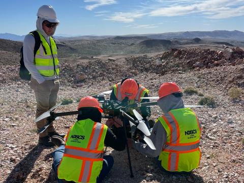
The Land Surveying and Civil Engineering Technology program prepares students for work as engineering and surveying technicians in construction-related industries, allowing graduates to work in a broad range of jobs such as surveying, drafting and material testing.

  • Type: A.A.S. degree
  • Locations: Wahpeton
  • Cluster: Architecture and Construction, Liberal Arts Transfer, Science, Technology, Engineering and Mathematics
  • Green Technology Available


» View Program Information & Admission Requirements

full


The Land Surveying and Civil Engineering Technology program prepares students for careers as surveying and engineering technicians in construction related industries. Students receive hands-on training with the cutting-edge equipment they will be using in the industry and can obtain positions as a surveying technician; civil drafting technician, GPS technician, or positions related to project quality control in just two years.

Students will experience hands-on learning experiences in land surveying, civil design and drafting using Autodesk Civil 3D, and quality control using the leading industry equipment and technology.

Land Surveying and Civil Engineering Technology Brochure